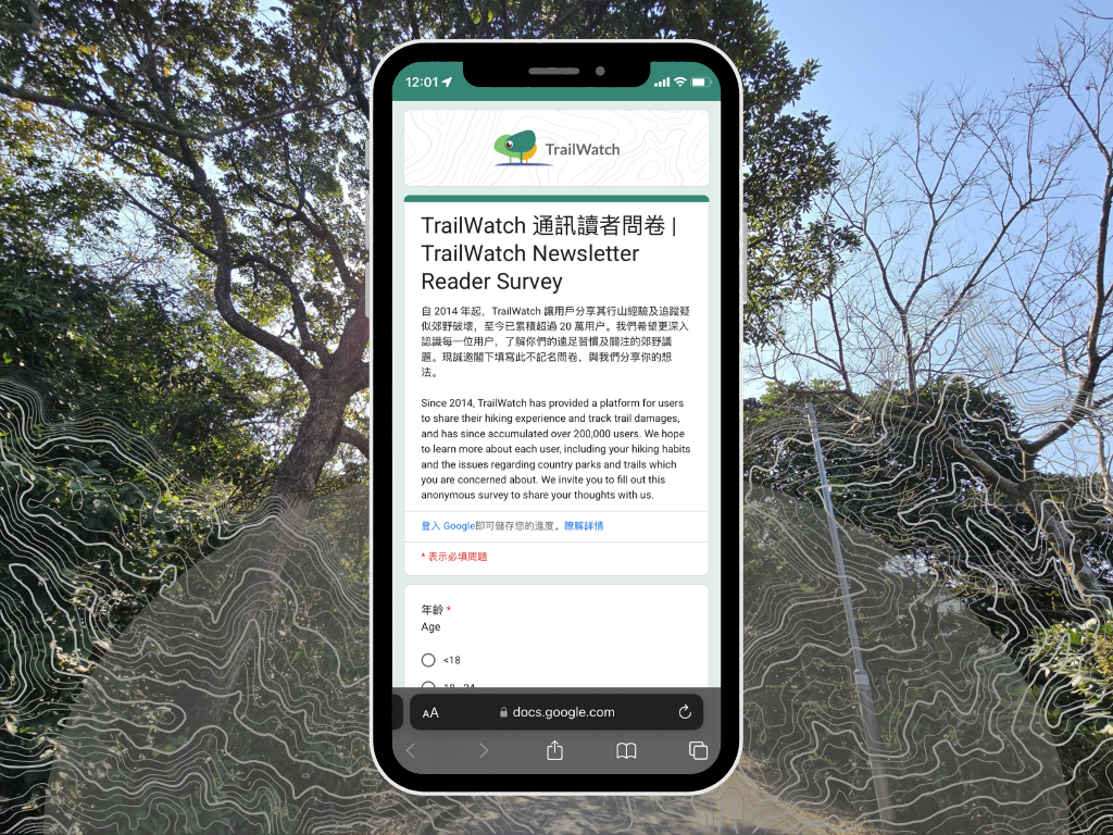
In the past ten years, our 200,000+ TrailWatch users recorded over 1 million activities. Recorded routes were over 1.2 million kilometers long, and activity records totalled over 7.5 million hours. TrailWatch’s tenth anniversary is the perfect chance for us to take a look at all the records accumulated in the past decade, and examine how Hong Kong’s hiking culture has changed.
1) Is hiking becoming more popular in Hong Kong?
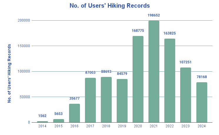
The hiking trend in Hong Kong has become a hot topic in recent years, and our decade-long data has witnessed the ups and downs of this phenomenon. As clearly shown by our data, the most notable hiking boom occurred during the pandemic period from 2020 to 2022, when the number of TrailWatch hiking records increased significantly, reaching a peak in 2021. Starting from 2022, the number of records gradually declined, returning to pre-pandemic levels in 2024. However, the fading of this trend doesn’t mean that the wear and tear caused by the crowds can simultaneously recover. The carrying capacity of Hong Kong’s countryside remains a concern worthy of continued attention.
2) Where do we hike?
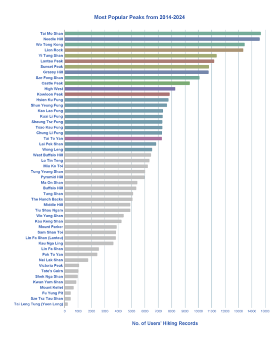
Which peaks are most popular among Hong Kong people? We looked at hiking records summiting Hong Kong’s 50 highest mountains over the past decade, and found that the 10 most popular peaks are as follows:
Note: The following ranking groups together peaks that are commonly hiked together. For example, the peaks within the Pat Sin Leng mountain range were all grouped under Pat Sin Leng.
- Tai Mo Shan – Including Tai Mo Shan (#1), Wo Tong Kong (#3) and Sze Fong Shan (#9)
Route for reference: 麥理浩徑第八段 | MacLehose Trail Section 8 - Needle Hill (#2) and Grassy Hill (#8)
Route for reference: 麥理浩徑第七段 | MacLehose Trail Section 7 - Lion Rock (#4)
Route for reference: 獅子山|Lion Rock - Sunset Peak – Including Sunset Peak (#7) and Yi Tung Shan (#5)
Route for reference:
鳳凰徑第二段 | Lantau Trail Section 2 - Lantau Peak (#6)
Route for reference:
鳳凰徑第三段 | Lantau Trail Section 3 - Castle Peak (#10)
- High West (#11)
Route for reference: 西高山 | High West - Kowloon Peak (#12)
- Pat Sin Leng – Including Hsien Ku Fung (#13), Shun Yeung Fung (#14), Kao Lao Fung (#15), Kuai Li Fung (#16), Sheung Tsz Fung (#17), Tsao Kau Fung (#18), Chung Li Fung (#19), together with and Lai Pek Shan (#22) and Wong Leng (#22)
Route for reference:
衛奕信徑第九段 | Wilson Trail Section 9 - Tai To Yan (#20)
Route for reference:
游走大刀屻 360度賞新界美景
3) Where else do we hike, other than summiting tall mountains?
Beyond peak-bagging, there are other ways to enjoy the countryside. Nature trails are one of the more accessible options, suitable for families with children and beginner hikers. These trails can also connect to other hiking routes while allowing visitors to learn about the local ecology, geological features, and cultural history along the way.
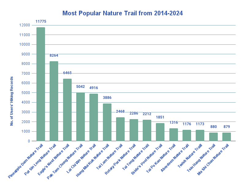
From 2014 to 2024, the three most popular nature trails among TrailWatch users are:
- Pineapple Dam Nature Trail
Route for reference: 菠蘿壩自然教育徑 | Pineapple Dam Nature Trail - . Pat Sin Leng Nature Trail
Route for reference: 八仙嶺自然教育徑 | Pat Sin Leng Nature Trail - . Eagle Nest Nature Trail Route for reference:鷹巢山自然教育徑 | Eagle Nest Nature Trail
Interestingly, when we look back at theanalysis done during TrailWatch’s fifth anniversary in 2019, these three trails were already the most popular nature trails among users at that time, demonstrating their lasting appeal. While these nature trails might appear modest at first glance, each offers its own unique scenery, ecological features, and distinct characteristics.
4) Hiking doesn’t always mean going far – How do we make use of our Backyard Trails?
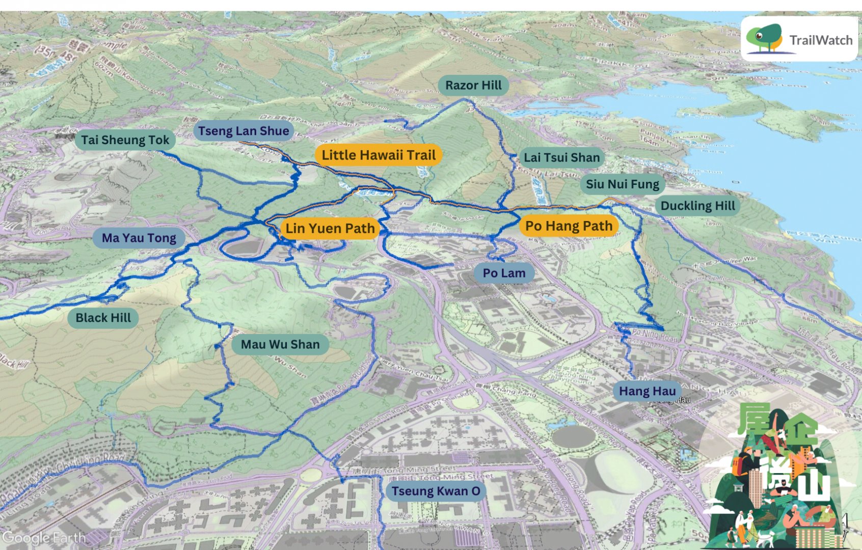
If you want to go hiking, besides venturing out to trails in Sai Kung or Lantau Island, you can also explore your own Backyard Trails! Backyard Trails refer to trails that are within a 15-minute walking distance from dense residential areas. These trails are not located within country parks or urban parks, but are typically in the green belt. Usually, they are frequented by nearby residents and morning exercisers. TrailWatch’s recommended routes section has recorded 34 Backyard Trails, including the Little Hawaii Trail and Po Hang Path to Lin Yuen Path (marked in orange on the map below).
The map below combines hiking records over the past decade for parts of the Little Hawaii Trail and Po Hang Path to Lin Yuen Path, showing us how these backyard trails are actually used. One key feature of Backyard Trails is that their starting points are highly accessible. These two trails are not only close to Tseung Kwan O, Hang Hau, and Po Lam, but also have various entry/exit points connecting to different nearby areas, allowing users to choose the most convenient access points to return to home.
User records show that routes can start or end at various locations including Tseung Kwan O, Po Lam, Hang Hau, Tiu Keng Leng, Yau Tong, Tseng Lan Shue, Clear Water Bay Wo Tong Kong, etc. The routes can also extend to peaks such as Duckling Hill, Siu Nui Fung, Razor Hill, Lai Tsui Shan, Tai Sheung Tok, Black Hill, and Mau Wu Shan, clearly demonstrating the interconnected nature of these backyard trails.
Learn more about Tseung Kwan O’s Backyard Trails: Backyard Trails: Duckling Hill – A Unique Community Gathering Space for Residents in Tseung Kwan
Route for reference: 小夏威夷徑 | Little Hawaii Trail、寶坑徑、蓮苑徑 | Po Hang Path and Lin Yuen Path
5) What problems is Hong Kong’s countryside facing?
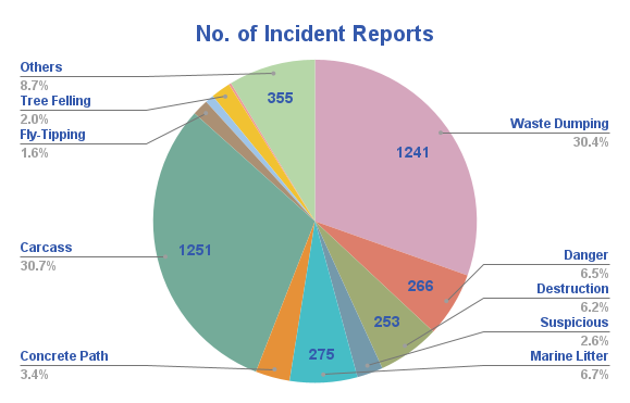
Besides planning, recording, and sharing hiking journeys, the TrailWatch app can also be used to report trail incidents. Over the past decade, TrailWatch has received the most reports about animal carcasses (1,251 cases), followed by waste dumping (1,241 cases) and danger (266 cases).
Among the numerous animal carcass reports, there were many cases of Hong Kong Newt roadkill. These reports came from a research team studying newt roadkill between March and May 2024, who used TrailWatch to record information such as locations, movement directions, and body lengths of newts and other animals killed on roads. Beyond allowing individual users to report incidents, TrailWatch also serves as a platform for various advocacy and research projects to record and analyze data.
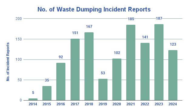
Although the hiking trend has had its ups and downs, we are grateful that TrailWatch users have continued to pay attention to countryside waste dumping issues and persistently report illegal dumping hotspots even as the hiking trend subsides.
Concluding remarks
A decade of data has provided us with valuable insights into how Hong Kong people use countryside areas and hiking trails, and how these patterns have changed over time. Only by clearly understanding the actual conditions of our countryside can we start discussing the trails’ carrying capacity, ways to promote the countryside, and policies for effective countryside management. While we might not be able to see into the future and predict how our countryside will look after another decade, what is certain is that everyone’s participation in and dedication to nature conservation continues to be pivotal.